
Mont Blanc: La voie royale (15.-18. Juli 2016)

Mont Blanc! The big mountain in Europe, tremendously appealing and so far from my alpine tastes at the same time. If anything, I had resolved in my first alpinistic days not to ascend it at any cost. I wanted it to be… enjoyable: allow time for acclimation, avoid the crowd of the normal routes, and if possible any alpine “public transport”. After a traverse of Domes de Miage several years ago, going further along this unique ridge (and ascending Mt Blanc via Aiguille de Bionassay) was in my mind! Descending via the Trois Monts route would make for an unforgettable tour (ZS, 12h to 18h depending on the topo).
Route:
http://www.gps-tracks.com/mont-blanc-la-voie-royale-sup%C3%A9rieur-alpin-tour-E06897.html

The taste of my first wild strawberries is quickly replaced by a cold, wintery feeling. The path is snowy from 2300m on… We reach the hut in the fog after spotting several ibexes.


An easy tour (WS), extremely diverse (glacier traverse, mixed ridge, snow ridge, and a nice horizontal rock ridge to the top) and perfect to gear up and get used to rope handling in rocky sections with 3 persons. Because it’s rarely visited nowadays, there are no crampons scratches to follow and we have fun climbing some nice pieces of rock on the first part of the ridge. We get our first glimpse on Aiguille de Bionnassay and Mont Blanc, very hairy with today’s wind!

Blick von Mont Tondu Sattel in Richtung Glacier de Tré de la Tête und Mont Blanc am Samstag auf unserer Zusatzetappe. Gut zu sehen sind auch die Windfahnen am Horizont

Blick nach Westen wo die Alpen schnell an Höhe verlieren

Ab dem Vorgipfel führt ein exponierter, aber leichten Felsgrat (I) zum Gipfel des Mont Tondu. Abstieg über die Normalroute (L)
 We’re back at lunch and take it as an opportunity to practice glacier rescue. Always useful (and sometimes fun!) to share tips and experience.

Im Hintergrund der Mont Tondu mit unserer Route über den NW-Grat. Fotografiert am nächsten Morgen

Follows a series of great ups and downs on Domes de Miage (WS), with a unique view to Mont Blanc and Aiguille de Bionnassay, getting always closer…
 Im Vordergrund: Aufstieg zum P.3673 am letzten Dôme de Miages. Im Hintergrund die Etappe vom kommenden Tag: Westgrat zur Aig du Bionnassay 4051 m ü.M. und weiter rechts unser zweiter 4000er, der Dôme du Goûter und schliesslich der Mont Blanc 4808 m ü.M. Am letzten Dôme in Richtung Cabane de Durrier gilt es Kletterstellen II zu überwinden (WS+)

Luckily, most people do the tour in the other direction, so we rapidly pass the crowd.

After skipping a (facultative) belay station and downclimbing the last bit of the rocky ridge to col de Miage, Claudio finds “the tunnel”; because he has gone through it we have to follow.

It’s narrow enough that Jessica and I get stuck one after the other; at least we give him an easy laugh! Picnic on the sunny slabs in front of refuge Durier and a nap… aaahhh the feeling of getting asleep in a small old-style hut after an early start and a great mountaineering day, I love this! The atmosphere in the hut is unusual, really packed (21 persons for 22 beads, only 11 seats around the table, hence 2 dinner services), with everybody going for the same route tomorrow. From today’s route and from the hut, the rocky section at the top of Aiguille de Bionnassay looks really steep and impressive!


Eine Stunde nach Aufbruch erreichen wir die bastion rocheux zur Aig du Bionnassay mit Schlüsselstellen III/ZS. Die Routenfindung ist einfach durch die vielen Steigeisen-Kratzspuren, zudem erlauben die ausgeprägten Zacken und Schuppen gut mit Schlingen abzusichern. 

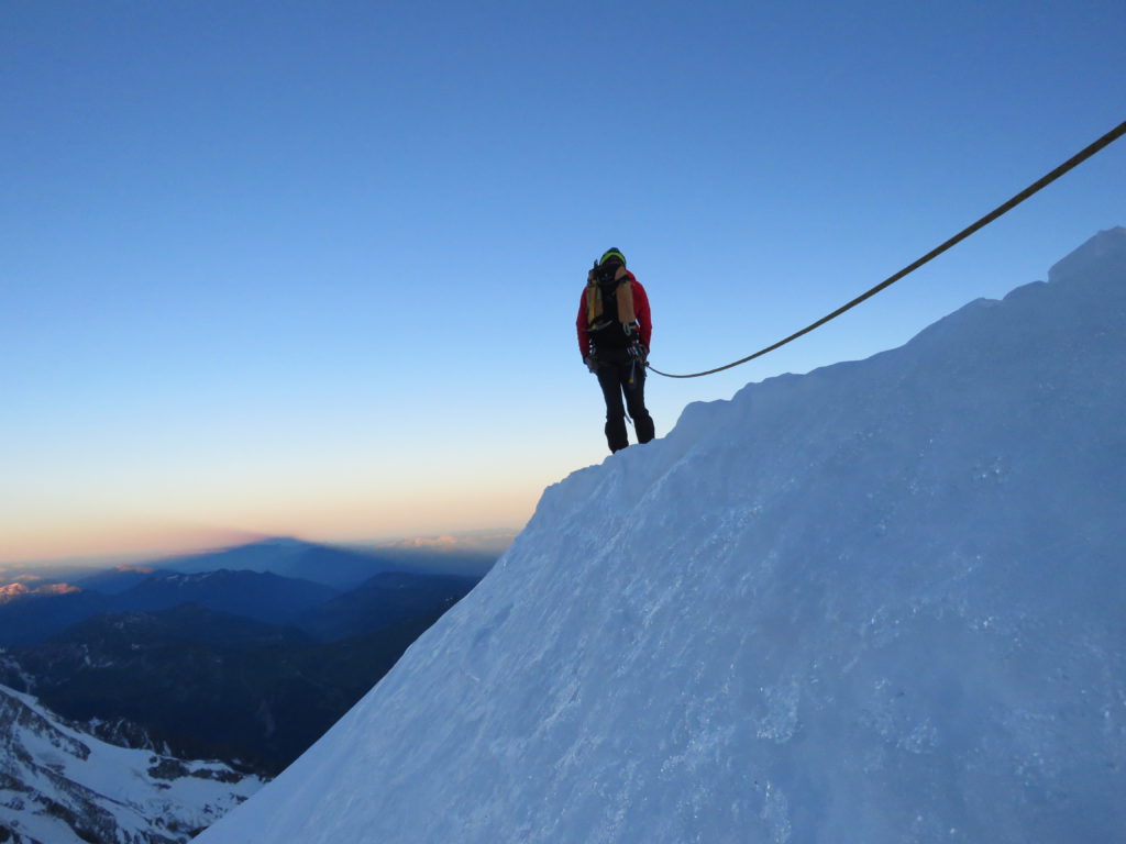
A short snow ridge takes us to the top. Follow the “exposed traverse with massive corniches”, luckily in perfect conditions. Vom Gipfel geht es über über den messerscharfen Ostgrat auf den Dôme du Goûter (3h) und auf die Normalroute zum Mont Blanc (2h)
 Although slower than expected on the rock (being three on a rope doesn’t help), we rapidly catch up to Pitons des Italiens and Dome du Gouter. From then on, Claudio’s main concern will be to keep us (from the back) at a reasonable pace to keep energy for the descent. The normal route is a deep, wide track, but not so much crowded anymore at this time of the day and we only meet a handful of zombies (either on their own or with their guide).


Nach 8h kamen alle 3 in Durrier gestarteten Seilschaften praktisch zeitgleich an, was uns zu diesem Foto veranlasste

Es folgte dann noch ein Monsterabstieg via Maudit und Tacûl (4-5h).

We start the descent to Col du Maudit, have a short picnic break, and keep going; we pass by a few more zombies pulled up by their guides: happy Mont Blanc!

At the pass, we join force (well… ropes) with other teams to set up a slightly messy rappel. From then on, I start feeling the long day, but there is still another descent, a traverse, a short ascent and then the famous serac-exposed N-face of Mont Blanc du Tacul. Claudio’s regular not-too-fast pace is invaluable to keep force and open eyes until the hut. On the large flat Col du Midi, we feel safe and like the day is over, still we’ll need some more power to reach the hut. What a unique day! 🙂

Für den Abschlusstag wollten wir was Kleines angehen, es kam anders und so sind wir via Aguille de Plan ganz ins Tal abgestiegen.

Man folgt dem Schneegrat von der Aiguille de Midi in den Col du Plan und ab hier exponiert in die Nordflanke auf Geröll oder Schnee unter dem Felsaufbau in den nächsten Pass (ZS).
Hier einem markanten Couloir ebenfalls in der NW-Flanke auf den P3601 folgen.
 Hier gilt es durch die Ostwand abzuseilen, wobei es unzählige improvisierte Abseilstellen gibt. Dank eines Seilklemmers durfte ich sogar noch ein bisschen in diesem tollen Granit rumklettern.

Wegen der fortgeschrittenen Zeit haben wir uns den Schlussaufstieg zur Aiguille du Plan geschenkt und sind direkt über den anspruchsvollen Gletscher abgestiegen. Auf 3200 m gibt es eine mühsame Spaltenzone zu queren. Früher wurde am östlichen Gletscherrand gequert, 2016 ist der westliche Gletscherrand besser. Für die Zukunft wohl ziemlich 50/50.
Von der Cab. Requin muss das Mer de Glace über luftige Leitern erreicht werden.


Séracs du Gèant
An dessen Ende wird wieder über luftige Leitern zur Bahnstation aufgestiegen, wo man den ultimativen Touri-Rummel erreicht, was uns so gestunken hat, dass wir spontan entschieden die Tour „bottom to bottom“ abzuschliessen und zu Fuss ins Tal abzusteigen. Bei 35°C in Hochtourenausrüstung. Da kam der Glacéstop gerade recht

Umbieter: Thomas Julou
TN: Jessica Plucain, Claudio Cadel
Text: Thomas (eng) & Claudio (deu)
Wunderschoene Tour! MB By fair means! Leute, ich bin unendlich neidisch, aber natuerlich sehr erfreut fuer Euch.
Nur weiter so in dem Stil – und lassen wir es im naechsten Sommer vielleicht mal wieder gemeinsam krachen, waere toll…
P.S.: Tourenberichte, die mit Glace/Kuchen enden bitte zukuenftig bei Hikr einreichen. 😉
Schön!